

OUR SERVICES
At 3dBIMdesign we scan, register and model existing buildings. Whether you need help with part of a project or need a job managed from start to finish, we can help you every step of the way.
3D LASER SCANNING
We provide 3D laser scanning services starting from just one day's work. Our scanning expertise spans a diverse range of projects, ensuring that regardless of your site, we can effectively capture it for you. Employing 360° data capture from various points around your building, our 3D laser scanning meticulously records every detail, from wall plugs to topographical features, in both monochrome and colour. This results in precise and measured data for your site, particularly valuable for planning renovations or building work.
With our commitment to thorough and accurate scanning, we stand ready to meet the diverse needs of your projects.
Moreover, our scanning capabilities extend to various sites, including:
• Heritage sites
• Properties of any size, including domestic and commercial structures such as offices and rental units
• Museums and galleries
• Bridges
• Outdoor grounds and outhouses

SCAN REGISTRATION
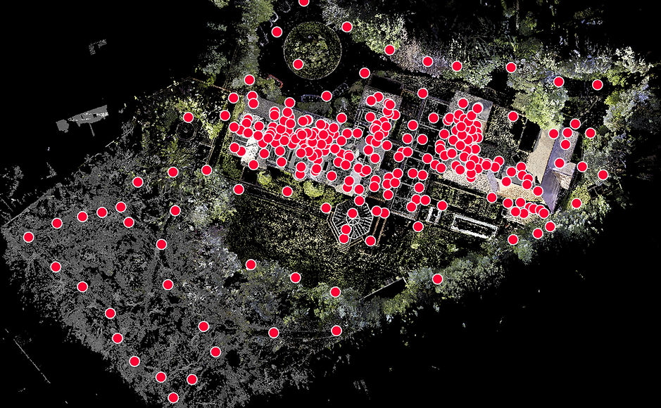
Whether we conducted the scans on your behalf or not, we can meticulously register scans using Cyclone, creating comprehensive Point Cloud data. This process encompasses topographical features captured by the laser scanner, providing a detailed representation of the site. If the scans were captured in color, we can accurately reproduce the images in their true colours. Our Point Cloud images, derived from 277 scan positions over a two-day scanning period, serve as ideal references for those requiring precise existing building plans. The thoroughness of the registration process ensures a reliable foundation for various projects and applications.
2D DRAWINGS
The 3D point cloud data can be converted into precise 2D CAD drawings, encompassing building facades, floor plans, sections, and elevations. These meticulously measured drawings serve as an ideal foundation for proposed building works and planning permissions. Additionally, they function as a comprehensive record of your building or site, providing valuable documentation for historical and preservation purposes. Our commitment to accuracy ensures that these drawings are reliable references for a range of applications in construction, design, and regulatory approvals.


TOPOGRAPHICAL SURVEY
Leveraging the advantages of 3D laser scanning in topography, our range of scanners has significantly elevated the speed, efficiency, and precision of surveying tasks.
With our array of scanners, including the Leica C10 with a range of up to 300m, we offer versatile solutions tailored to the unique requirements of topographical surveys.
The resulting point cloud proves invaluable, allowing for a comprehensive analysis of the entire 3D environment. This diverse set of scanners enables us to obtain precise dimensions and accurate object positions, providing a robust foundation for topographical assessments and land surveys.

3D BIM MODELLING
Additionally, we have the capability to convert the fundamental Point Cloud data into an intricately detailed 3D BIM model using software such as Revit, ArchiCAD, or SketchUp. This process involves meticulous colour and texture-matching to meet specific requirements. Our 3D models go beyond the basics, incorporating finer details like wall plugs and light fittings, ensuring a comprehensive representation of the built environment. This level of precision is particularly beneficial for architects, designers, and stakeholders involved in detailed planning and visualization of construction or renovation projects.


Our approach has allowed us to develop a process which helps us deliver fast and accurate Building Information Model. 3D BIM Design vast experience in utilising 3D Laser Scanning technology, our workflow process and technological enhancements make us an industry competitor with the ability to provide and implement range of BIM deliverables including Autodesk Revit. Our dedicated team is highly experienced within the construction and design industry and our BIM models contain rich database of information required in the later stages of projects.


As a BIM service provider we use the newest version of Revit to adopt best tools to provide professional BIM services. We can adjust to clients standards, templates and work with all versions of Revit to ensure files compatibility. By using Revit modelling tools we can deliver not only building model but also models of MEP system, site terrain models with all landscape objects modelled in a detail model suitable for the client ( LOD – 100, 200, 300, 350 ).


ArchiCAD was first introduced in 1982 by the company Graphisoft, which was the first BIM software available for commercial use. Until 2000, Archicad was used mainly in smaller projects, while through a series of improvements and additions, like the GDL objects and the Cinema 4D Render engine, ArchiCAD became the preferable software of thousands of users across the world.
As a BIM service provider we use the newest version of Archicad and Revit to adopt best tools to provide professional BIM services. We can adjust to clients standards, templates and work with all versions of Archicad to ensure files compatibility. By using Archicad modelling tools we can deliver not only building model but also models of MEP system, site terrain models with all landscape objects modelled in a detail model suitable for the client ( LOD – 100, 200, 300, 350 ).
Trimble SketchUp is an intuitive 3D modelling application that lets you create and edit 2D and 3D models with a patented "Push and Pull" method. The Push and Pull tool allows designers to extrude any flat surface into 3D shapes. All you have to do is click an object and then start pulling it until you like what you see. SketchUp is a program used for a wide range of 3D modelling projects like architectural, interior design, landscape architecture, and vide game design, to name a few of its uses.


As a BIM service provider we use the newest version of SketchUp to adopt best tools to provide professional BIM services. We can adjust to clients standards, templates and work with all versions of SketchUp to ensure files compatibility. By using SketchUp modelling tools we can deliver not only building model but also models of MEP system, site terrain models with all landscape objects modelled in a detail model suitable for the client ( LOD – 100, 200, 300, 350 ).


Lumion is a powerful rendering software widely acclaimed for its real-time rendering, user-friendly interface, and high-quality visualizations. It allows architects and designers to effortlessly transform 3D models into immersive and realistic presentations. Lumion's key strengths lie in its dynamic lighting, extensive asset library, and seamless integration with popular 3D modeling software, making it an ideal choice for efficiently showcasing architectural projects with compelling realism.


